
Discover the Ray Pic waterfall, a geological gem located in the heart of the Ardèche in the Bourges valley. This exceptional site offers an unforgettable experience of essential splendour, sure to delight nature lovers and fans of volcanic landscapes.

The Ray Pic waterfall?
The Cascade du Ray-Pic is a geological wonder formed by a spectacular waterfall fed by the Bourges river. It rises at the foot of the highest village in the Ardèche, Lachamp-Raphaël, before tumbling down to the tributary of theArdèche, the Fontaulière.
Nestling at the foot of the Suc de la Sapette in the heart of a beech forest, the avalanche of water set against a mineral backdrop reveals a sumptuous landscape where the flow of the river rushes through a magnificent setting ofbasalt organs. The waterfall is surrounded by lush, unspoilt vegetation, offering visitors a veritable haven of peace.
And to get things off to a good start, here are a few images of the waterfalls from above:
Ray Pic in figures
The foot of the waterfall is 973 metres above sea level, and the peak above it, the Sapette, is 1,282 metres above sea level. With a total height of 60 metres, the main waterfall jumps 35 metres to the river.
Classified as a natural volcanic site in 1931, Ray-Pic welcomes 130,000 visitors a year, particularly during the summer months. It is ideally situated between the Ardèche plateau, with the Mont Gerbier de Jonc natural volcanic site, and the southern Ardèche, with the river of the same name ideal for swimming and canoeing.
Parking for the Ray-Pic waterfall is 37 kilometres from Aubenas*, 45 from Privas, 34 fromIssarlès lake, 15 from Mont Gerbier de Jonc* and 30 from Mont Mézenc*.
From the car park, at an altitude of 1,005 metres, it will take you around 15 minutes to walk to the observation points opposite the waterfall.
Geological history
The volcano at the foot of the Fialouse, also known as the Ray-Pic* maar, has a diameter of 1,200 metres and erupted around 78,000 years ago, during the Holocene* period.
With a basalt flow 21 kilometres long and exceptional in Europe, the waterfall is the high point of the region, with 7 observation points for geology enthusiasts and landscape lovers, along the Bourges valley, through Fontaulière to the Ardèche valley.
As well as the tourist site in Péreyres, this unique basalt formation can be seen at the sites* of Payral, Pont de Chastagnas, Burzet, Lamadès,Amarnier and Pont-de-Labeaume.
Geological focus with the Monts d’Ardèche Regional Nature Park*.The organs from which the two Ray-Pic waterfalls gush out are prismatic in shape: the erosive action of the river has cleared the rock at the point where the crater rim meets the lava lake. The river then carved out its bed, cutting through the centre of the former basalt lake.
The volcano first erupted in a phreatomagmatic explosion (see below) and then evolved into a strombolian dynamism. In its final, more effusive phase, the lava invaded the entire crater, creating a lava lake and then overflowing into the Bourges valley.
A phreatomagmatic explosion?
Source: Geopark des Monts d’Ardèche
A volcanic eruption in which magma at a temperature of around 1100°C comes into contact with surface water. The immediate and sudden vaporisation of the water leads to violent explosions that pulverise the bedrock and fragment the lava emitted, giving rise to projections, mixtures of ash, cauliflower bombs and bedrock, which accumulate around the crater and form a volcanic rift.

History of the discovery
In 1751, on their return from Italy, where they had observed active volcanoes, Jean-Etienne Guettard and Chrétien Guillaume de Lamoignon de Malesherbes, both geologists at the Royal Academy of Sciences, stopped off in Montélimar. They observed workmen paving the streets with the same rock they had studied in Italy, basalt. From there, our two naturalists were taken to a quarry in the Coiron: there was no doubt that they were looking at an ancient lava flow.
That same year, after discovering the volcanic nature of the Puys chain, Jean-Etienne Guettard* published Mémoires sur quelques montagnes de la France qui ont été des volcans.
In 1775, Barthélemy Faujas de Saint-Fond and Jean-Etienne Guettard discovered theAntraigues-sur-Volane flow in the Ardèche and the Aizac bowl*.
In 1778, Barthélemy Faujas de Saint-Fond wrote a magnificent work: Recherches sur les volcans éteints du Vivarais et du Velay*. The descriptions of the sites are enhanced by superb engravings showing the flows in the Volane,Ardèche and Lignon valleys.
The scientific enthusiasm generated by this revelation then led to the Velay andAuvergne regions, where the volcanic forms are now clearly visible.
Source: Ray-Pic interpretation panel, Gilbert Cochet and CPIE du Velay.
The first description of the volcano was written by Jean-Louis Giraud-Soulavie, the first inventor of the Ray-Pic site:
“This volcano is situated on the southern extremity of the upper volcanic plateau of the mountain. Its lavas were precipitated into the Burzet valley, where they offer some very magnificent views.“
It will also reveal the volcanic nature of Mont Gerbier de Jonc.
Source: Histoire naturelle de la France méridionale by Abbé Giraud-Soulavie, 1780

Ray-Pic and practical information
Here’s some practical information for your visit to Ray-Pic, including itineraries, suggestions and the weather.
How do I get to the Ray-Pic waterfall in the Ardèche?
By car, bus or on foot, all the paths in the Bourges valley lead to the waterfall!
By car
There is only one road leading by car to the Ray Pic gorge on the southern flank of the Ardèche mountains: the D215, which links the villages of Burzet and Borée.
You can reach the site from the Massif-Central on the N88 national road, from the south of the Ardèche on the N102 national road, or via the Rhône valley on the N7 national road or theA7 motorway ( Montélimar north, Loriol-sur-Drôme or Valence south exits).
You can consult the interactive road route maps here.
By bus
The nearest village accessible by bus is Burzet, 12 kilometres from the waterfalls. The E16 line of the Ardèche bus service will take you there fromAubenas or the following villages along the way.
On foot
From the Ardèche plateau or the village of Péreyres, there are several walks that take you to the waterfalls along the Bourges and Ardèche mountain trails: see the map.
You can also simply head off from the car park along the shortest path, as described in the text and map on this page.

What on-site services and facilities are available?
There are two car parks on site, close to the pedestrian walkway.
It should be noted that the path is signposted and equipped, but that it is not accessible to people with reduced mobility, particularly as there are a number of steps.
During the summer months, there is a picnic area below the entrance to the site where you can stop for a snack, as well as higher up on the lookout (see map below). Toilets are also available at the entrance to the trail.
An educational area at the start of the path to the waterfall provides information on the history and geology of the site, with additional panels along the way.
In 2009, following a fatal rock fall , the site was closed for two years to improve safety. Since then, it has been strictly forbidden to leave the path or venture to the foot of the waterfall outside the observation lookout.
Practical advice and visiting periods
The site is open to the public all year round, except in the case of climatic events or rockslides on the site.
Although access to the belvedere is fairly quick, between 10 and 20 minutes depending on your walking pace, it is strongly recommended that you have walking shoes or at least sports shoes.
The terrain is quite steep, particularly on the steps up and down to the lookout point, which can be wet and slippery after rain.
The site is pleasant to visit all year round.
In spring, you’ll see lush green vegetation and the first flowers. Assummer approaches, the colours of the broom and heather will colour the landscape. At the height of the summer season, it’s a uniquely cool spot, between the shade of the beech groves and the rush of the waterfall.
During periods of heavy rain or melting snow, in spring or during the Cévennes rains inautumn, the waterfall exults with all its power and its immense scarf of white foam with its grandiose sounds.
Finally, inwinter, in snowy years, you can enjoy a magical spectacle of waterfalls, ice and white snow.
Where to sleep?
If you’re looking for a hotel, gîte or rental nearby, visit the page on where to sleep in the Ardèche to find the accommodation of your choice to suit your needs and budget:


What’s the weather like at the Ray Pic waterfall?
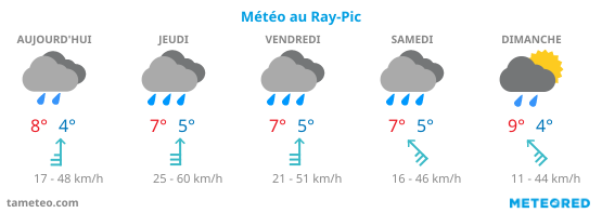
Here is the 5-day weather forecast for the commune of Péreyres near the site :
Practical Ray-Pic
- Where to stay at Ray-Pic
- Map of routes to Le Ray-Pic
- IGN map of the Ardèche : 2837 OT Lac d’Issarlès, Thueyts
Map of walks and facilities
Map of access to the Ray-Pic by car or on foot from Péreyres, viewpoints and climbing sites nearby:
- The Monts d’Ardèche Regional Nature Park
- The Fialouse and Aizac cuts , Monts d’Ardèche Geopark
- Ray-Pic volcano and maar flow(PDF format), Nature France
- Jean-Etienne Guettard: the beginnings of geology, Gallica
- Research into the extinct volcanoes of Vivarais and Velay, Gallica
- The Holocene waterfall via Wikipedia