
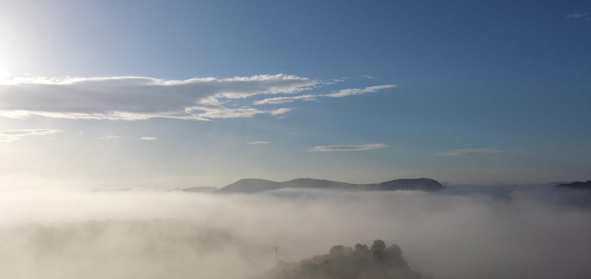
The Ardèche has the image of a department where people come to breathe, between valleys, gorges and plateaux. However, behind the cliché of pure air, air quality remains a very real issue, one that needs to be measured, mapped and monitored on a daily basis, given the diversity of the areas that make it up. Here’s a closer look at the air in the Ardèche.

A rural area… crossed by flows
Seen from a distance, the Ardèche combines a number of environmental advantages: no metropolises or large towns, few large continuous industrial zones, and one of the lowest population densities in Auvergne-Rhône-Alpes, after Cantal, Haute-Loire and Allier. So, in theory, all the lights seem to be on when it comes to air quality. But the reality of air quality in the Ardèche is more nuanced.
The north of the department, and more specifically the Annonay basin, looks towards Saint-Étienne, the Gier and Rhône valleys (or chemical valley in this part) and the Lyon metropolitan area, with which air masses are constantly exchanging.
On the eastern fringes of the Ardèche, the Rhône valley acts as a corridor, with heavy traffic on theA7 motorway, industrial estates and conurbations such as Valence, Romans-sur-Isère and Montélimar, whose emissions sometimes influence the Ardèche banks through the effect of the winds.
Further south, the influx of tourists, particularly in the high season, occasionally increases travel and therefore transport-related emissions.
Away from these major routes, the hinterland and plateau of the Ardèche benefit from a more unspoilt environment, with lower pollution levels overall, even though certain regional episodes, particularly those linked to ozone or fine particles, can affect the whole of the département, the higher the altitude and the further away from the Rhône valley.
Air and its flows know no departmental signs or clear borders: it moves at the whim of winds, relief and meteorological situations.
What do we measure when we talk about air quality?
Behind the expression “air quality” lies a set of pollutants that are monitored in a precise and standardised way. In France, with the Atmo France network, an overall index summarises several regulated compounds, with a scale ranging from good to extremely poor.
The main pollutants monitored include :
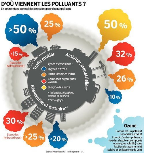
- Fine particles and emissions, mainly from wood heating, road traffic, certain industrial and agricultural activities, but also from larger-scale phenomena (desert dust, transport of pollution from other regions or countries).
- Nitrogen dioxide is strongly linked to vehicle emissions, particularly on busy roads and near urban areas.
- Ozone is a rather unusual pollutant because it does not come straight out of an exhaust pipe: it is formed in the atmosphere from other pollutants under the effect of the sun, and is particularly noticeable during the summer months, when the weather is hot and sunny.
- To a lesser extent, other compounds such as sulphur dioxide or certain specific organic compounds (benzene, PAHs, etc.) are also subject to regulatory or health monitoring.
The World Health Organisation (WHO) has increased its recommendations for 2021, particularly for fine particles, with annual thresholds that are much stricter than in the past, given the consequences for health.
The Atmo Auvergne-Rhône-Alpes reports show that, in the Ardèche, the French regulatory values are being complied with at the reference stations, but that the new WHO thresholds for particulates PM2.5 are still frequently exceeded for a significant proportion of the population.
A regional observatory for the Ardèche
In Auvergne-Rhône-Alpes, air quality monitoring is the responsibility of Atmo Auvergne-Rhône-Alpes(AuRA), an accredited association covering the region’s twelve départements, including the Ardèche. Its mission is to measure, model, inform and warn in the event of pollution episodes, in conjunction with the State and local authorities.
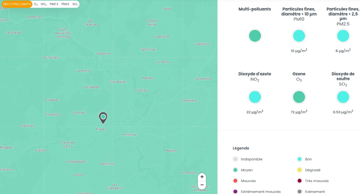
In practical terms, Atmo AuRA relies on a network of permanent and temporary measuring stations, which operate 24 hours a day, 7 days a week across the region’s départements. These stations continuously analyse pollutant concentrations (NO₂, O₃, PM₁₀, PM₂.₅, SO₂) and serve as the basis for air quality analysis models.
Screenshot 24/02/2026
In the Ardèche, the situation is special: there are no longer any permanent Atmo measurement stations for the four main pollutants in the department itself, and the most recent analyses are based on a regional network and mainly on stations in the neighbouring department, the Drôme.
Historically, however, stations have been set up in Aubenas and Annonay for long campaigns, as well as in Saint-Bauzile to monitor an industrial site. These measurements have helped to characterise local pollution profiles, which are then used as a reference for models.
The maps and indices that the general public consult every day therefore combine three types of data:
- Direct measurements from stations in the region (including neighbouring departments).
- Detailed emission inventories (traffic, heating, industry, agriculture, etc.).
- The weather, which controls the dispersion or accumulation of pollutants.
Air quality in the Ardèche: local authority and region
For individuals, the easiest way to access the Atmo Auvergne-Rhône-Alpes website is to use the search engine by address and commune. Simply enter the name of the village or town in the Ardèche of your choice, or its postcode, to obtain the day’s index, short-term forecasts and prevailing pollutants.

Screenshot 24/02/2026
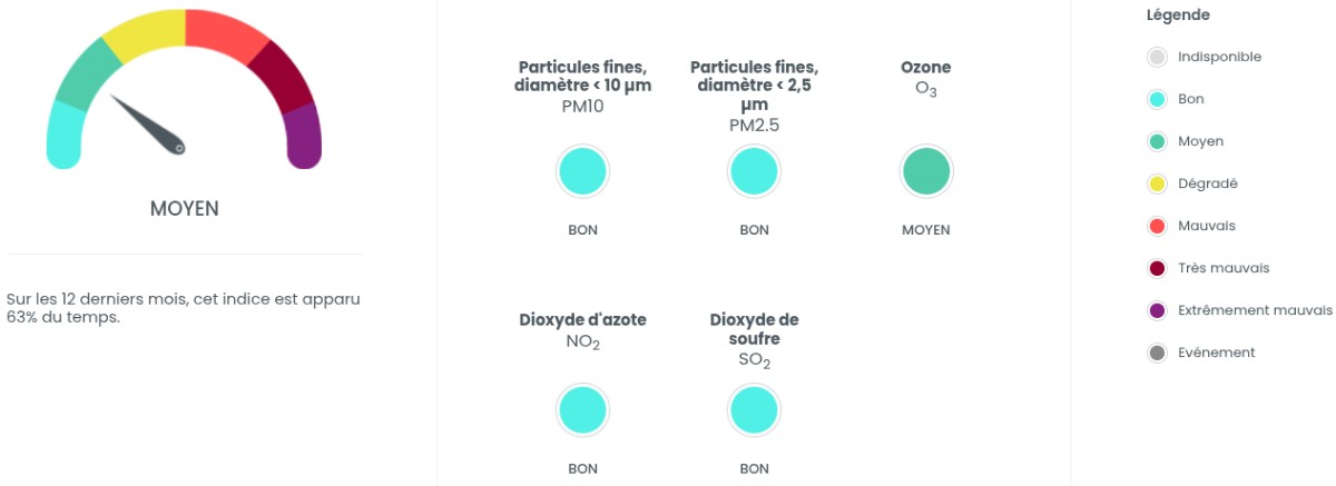
Based on this search, on each local authority page you will generally find :
- The day’sair quality index, presented on a coloured scale
- The respective shares of the main pollutants in this index
- A recent 12-month history, useful for putting a one-off event into perspective and obtaining an annual average.
Screenshot 24/02/2026
- A detailed map of global forecasts and forecasts by pollutant, with hourly forecasts
Screenshot 24/02/2026
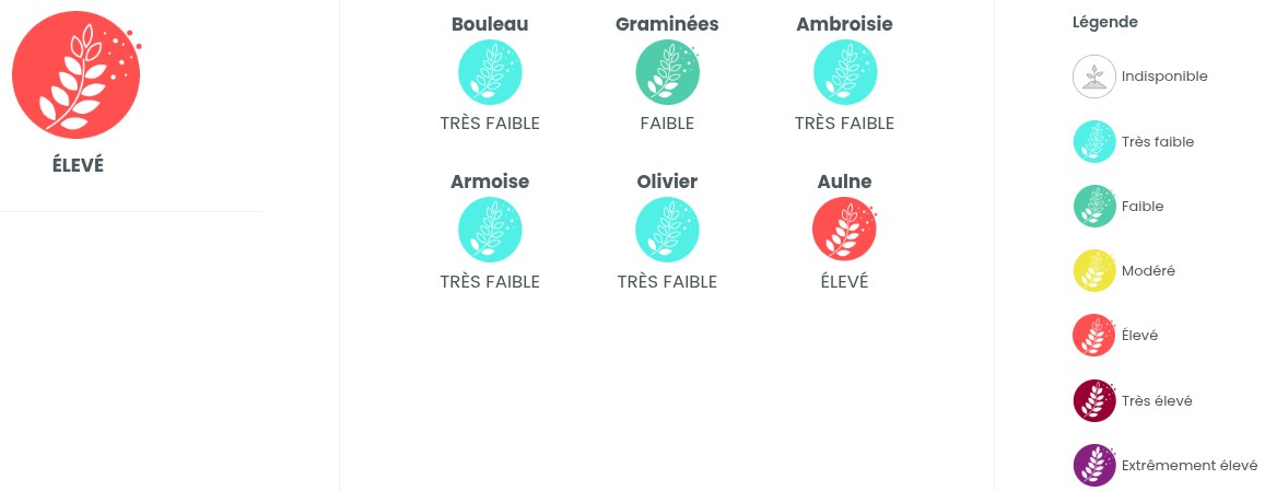
- The pollen risk index, with the types of pollen concerned:
birch, grass, ragweed, mugwort, olive, alder
Screenshot 24/02/2026
- Explanations of the benchmark values and recommendations(air Attitude).
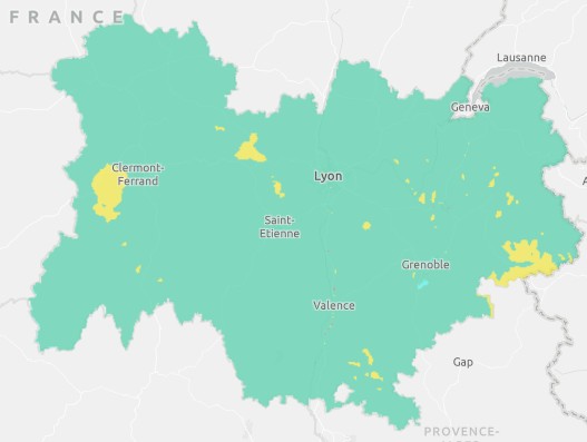
A regional map also allows you to see at a glance the indices for the whole Auvergne-Rhône-Alpes region, so you can compare the Ardèche with its immediate neighbours (Drôme, Loire, Haute-Loire…). This type of view is invaluable for those who move around a lot during the day or week, for work or leisure.
The Atmo-France portal* also provides national access to air quality, with links to regional observatories and a unified index map.
Finally, global platforms such as AQICN aggregate data from public bodies and local sensor networks to produce (near) real-time pollution maps of countries, including France.
However, these global maps must be interpreted with caution, as they sometimes mix sources of varying quality. For a well-founded local diagnosis, Atmo by region remains the reference.
An area of contrasts: Rhône valley, urban centres and hinterland
The most recent air quality assessments carried out by Atmo Auvergne-Rhône-Alpes for the Ardèche region highlight a number of trends.
First, ozone * is a major issue for Drôme and Ardèche, which are among the most sensitive departments in the region to this type of pollution. Summer sunshine, hot spells and the circulation of air masses in the Rhône valley encourage the formation and transport of this pollutant, with WHO recommendations regularly exceeded, mainly during the summer months.
Then, the particles and * show an overall improvement over the long term, under the combined effect of regulations, changes in industrial practices and efforts on domestic heating.
However, the new WHO thresholds for fine particles are still exceeded by a significant proportion of the population of the Ardèche, particularly near major roads and industrial areas, which shows that there is still real room for improvement.
Finally, some sectors are more exposed than others:
- Towns close to the Rhône valley, where traffic, business parks and corridor effects combine.
- Urban centres such as Aubenas or Privas, where traffic and individual heating can have a greater impact on the indices on unfavourable days.
- Specific activity zones around industrial sites, where monitoring is stepped up (as was the case at Saint-Bauzile).
Conversely, the mid-mountain areas, plateaux and low-density sectors still have more favourable overall levels and less pollution, although they are still affected by major regional episodes of ozone or particulate matter.
When good weather doesn’t mean fresh air
It’s a paradox often observed in the Ardèche, as elsewhere: bright days, sometimes spectacular in the mountains, can be matched by air quality indices that are sometimes mediocre. The cause lies in the weather.
In winter, calm anticyclonic conditions, with little or no wind, encourage temperature inversion. Cold air settles in the valleys, trapping pollutants close to the ground. Emissions from heating and traffic are poorly dispersed, which can accentuate the presence of particulate matter. and *even far from major urban centres.
In summer, heat and sunshine act as a chemical catalyst for ozone *. The precursors emitted in urban or industrial areas can be transported and transformed into ozone, sometimes dozens of kilometres downwind, including over rural areas or hills popular with walkers. A fine day’s holiday in the southern Ardèche can therefore coincide with an ozone episode, which may not be very noticeable to the naked eye, but is very real for the most sensitive respiratory tracts.
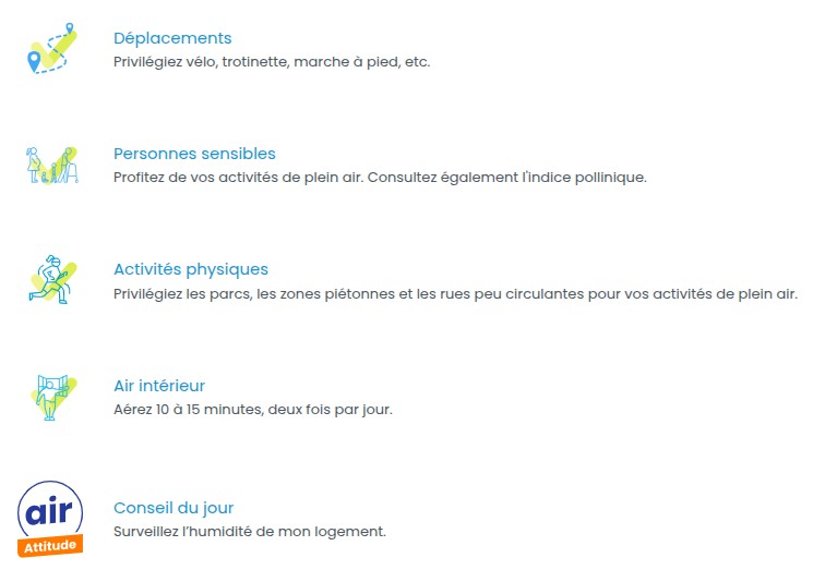
How can you adapt your activities in the event of an episode?
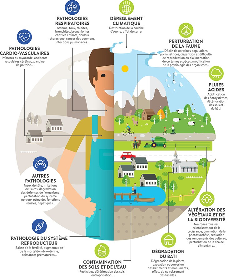
Without giving in to doom and gloom, a few simple reflexes are recommended in the event of a pollution episode, especially for the most vulnerable people (children, the elderly, pregnant women, people with asthma or suffering from respiratory or cardiac pathologies).
- Adapt the intensity of your exercise: avoid very intense training on days when the index is poor, and opt for more moderate activity.
- Avoid the most exposed routes: when running, walking or cycling, choose backstreets, paths or nature trails rather than busy roads, especially at rush hour.
- Choose the right window of opportunity: in the case of ozone, concentrations tend to be higher in the late afternoon; for some particulates, peaks can coincide with periods of intense heating or heavy traffic.
- Keep an eye on the forecasts: by consulting the Atmo map the day before, it is often possible to postpone an outing by a few hours or choose a slightly less exposed area.
Screenshot 24/02/2026
The Ministry for Ecological Transition, via Atmo-France, publishes general information and health recommendations on air pollution on its portal*, which is a useful complement to the regional bulletins.
Reviews and reports: taking a step back from trends
While the daily indices give a snapshot at a given moment, the Atmo Auvergne-Rhône-Alpes departmental assessments and reports provide a longer-term view of air quality in the Ardèche.
They include*:
- Changes in concentrations of each main pollutant over several years
- The number of days on which certain regulatory or recommended thresholds are exceeded
- The most exposed neighbourhoods or areas, where the density of measurements permits
- Summary analyses by department, including the Ardèche.
For a broader view of the Drôme-Ardèche region, Atmo AuRA also publishes cross-regional diagnoses, which take into account the dynamics of the Rhône Valley.
Citizen action: the Captothèque and the air in its area
For several years now, Atmo Auvergne-Rhône-Alpes has been offering the general public an original service: the captothèque*. This is a service for measuring air quality for the general public, enabling anyone to borrow a mobile micro-sensor free of charge in order to carry out their own observations, according to the needs of each region.
There are a number of objectives:
- Raising awareness of air quality issues through direct experience
- Help to compare situations (a street with heavy traffic / a quiet street, a neighbourhood at the bottom of a valley / a plateau, etc.).
- In some cases, support citizen observatories with fixed sensors installed in partnership with local authorities, associations or businesses.
The micro-sensors do not replaceAtmo AuRA‘s reference stations, which are much more accurate and calibrated, but they are a powerful educational tool for understanding the variability of the air we breathe on a daily basis.
Between rural assets and health vigilance
When it comes to air quality, the Ardèche still has some serious advantages over other more densely urbanised or industrialised areas of the Auvergne-Rhône-Alpes region. The absence of a major metropolis, the importance of natural areas and the diversity of relief all help to limit certain phenomena.
However, the air in the Ardèche is not free from pollution, nor is it disconnected from regional dynamics. Ozone episodes in summer, particle peaks in winter, and the influence of the Rhône Valley and its flows all require careful monitoring, whichAtmo AuRA andAtmo-France tools make available to everyone.

Air quality and links in the Ardèche
Here’s some information, direct links and an application for monitoring air quality in the Ardèche, the Drôme, the Auvergne-Rhône-Alpes region and France.
Air quality: main towns in the Ardèche
Summary of the day and direct links to more detailed information and forecasts
- Annona y
- Aubenas ↗
- Guilherand-Granges ↗
- Tournon-sur-Rhône ↗
- All communes ↗
Air to Go, air quality on your mobile

Developed by a consortium of Air Quality Monitoring Associations, Air to Go offers you the information and tools you need to make air quality your ally in improving your quality of life. Thousands of people in 5 regions of France are already benefiting from this free, constantly evolving service.


- Typology of pollutants: NO2, O3, PM2.5, PM10, SO2
- Air quality by department ↗
- Publications and reports, Atmo Auvergne-Rhône-Alpes ↗
- The Captothèque, a citizen’s measure of air quality ↗
- National air quality monitoring by region, Atmo France ↗